Natural and Cultural Resources
Cultural Resources
Historic Structures
Fairfax has many older homes and historical buildings indicating a rich past. The Division for Historic Preservation has placed many homes, farms and buildings; as well as the Fairfax Falls, Fairfax Village and Brown's River bridges in the Vermont State Register of Historic Places. Although the covered bridge located on Maple Street is not listed in the register it is an important part of the village landscape. The Vermont State Register is available for review at the Town Clerk's office. It contains the location of all the historic sites within the Town. Unfortunately, we have lost several. These were: Rood House, McClure House, and the Howell House. The Fairfax Bridge and the Browns River Bridge were replaced for safety reasons.
In addition to individual properties listed in the register, the Fairfax Village Historic District is defined as having approximately the same boundary as the Village of Fairfax when it was first laid out in 1820. Today, the district encompasses all of Maple, School, and Hunt Streets, as well as a portion of Fletcher Road, and all of Main Street from near the Lamoille River to just north of Buck Hollow Road. The area from Huntville to the northwest corner of the McCoy property is the only area in the village that is not included in the Historic District. Historic sites in the Town, their location, and site number are shown in Table 1, below.
Note: Table 1 is not an official list of all Historic Properties, and some omissions may occur. An official list, which is updated as new properties are added, is available for review in the Town Clerk's Office.
|
Table 1. Registered Historic Properties in the Town of Fairax |
||||
|
|
Site Name |
Location |
Site # |
|
|
Drinkwine-Roig House |
Carroll Hill |
1 |
||
|
Gillan-Kuhn House |
2 |
|||
|
Webb Farm-Maplewood Dairy |
Buck Hollow |
4 |
||
|
Rugg-Austin-Webb House |
5 |
|||
|
Coddings House |
6 |
|||
|
Parsonage-Collins House |
7 |
|||
|
Ovitt House |
8 |
|||
|
Buck-Ovitt Place |
11 |
|||
|
Bludgeon Farm |
13 |
|||
|
Rood House |
Rood Mill |
9 |
||
|
Hunt-Dufford-Meade House |
Mead Road |
12 |
||
|
Wycoff-Irwin House |
Huntville |
14 |
||
|
Wheeler-Heyer Farm |
15 |
|||
|
Learnerd-Martin-Wold House |
16 |
|||
|
Woodward Farm-Echo Valley |
18 |
|||
|
Howard-Blum House |
19 |
|||
|
Tabor House |
Tabor Hill |
20 |
||
|
Wilkins Farm |
Wilkins Road |
21 |
||
|
Megars-Tanner House |
Fletcher Road |
22 |
||
|
Clokey Farm |
23 |
|||
|
Methodist Parsonage |
43 |
|||
|
Wilson-Tracey Farm |
24 |
|||
|
Maxfield-Faymond House |
25 |
|||
|
Old Minor House |
26 |
|||
|
Chaffee House |
River Road |
27 |
||
|
Lovegrove-Zeno House |
28 |
|||
|
Cameron House |
29 |
|||
|
Howell Place |
31 |
|||
|
Fairfax Falls Bridge |
Fairfax Falls |
32 |
||
|
Bernard Bessette House |
Goose Pond |
33 |
||
|
Bishop-Goldsmith House |
34 |
|||
|
Maxfield House |
35 |
|||
|
Prindle-Maxfield House |
36 |
|||
|
Foss-McNall House |
McNall Road |
40 |
||
|
Billado Farm |
Richards Road |
41 |
||
|
Fairfax Historic District |
44 |
|||
|
Parsonage-Ballard-Langelier House |
Rte 104 |
45 |
||
|
James Bellows Farm |
46 |
|||
|
Giddings-Wimble Farm |
37 |
|||
|
Dezotelle House-Old Stone |
38 |
|||
|
Gerald Minor House |
39 |
|||
|
Bouthilette Farm |
50 |
|||
|
Bailey House |
51 |
|||
|
Bessette House |
52 |
|||
|
Orton-McNall House |
53 |
|||
|
Parah House |
54 |
|||
|
Ayers-Bessette House |
55 |
|||
|
Boucher House |
56 |
|||
|
Duval House |
57 |
|||
|
Magnan House |
58 |
|||
|
Hibbard House |
60 |
|||
|
Pease-Ladoux House |
Nichols Road |
59 |
||
|
Source: Vermont Division for Historic Preservation, 1989. |
||||
The following was excerpted from the 1996 Annual Town Report. The extensive historical information presented below was collected through citizen volunteer efforts. The report was submitted by Donna Meunier.
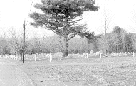
In addition to Fairfax's historic structures numerous cemeteries are located around the town. A complete listing of all stones, the information on them and a map of each cemetery is in the town office. Since a lot of the writing on the stones was becoming unreadable, and many of the stones had fallen or were damaged, volunteers went to each cemetery in Fairfax during the summer of 1996. They tried to record all legible information before it was lost forever.
Henry Raymond tied a good deal of this information, such as the names of a spouse and children, into the genealogy work he had been doing. Included here is a listing of our cemeteries, the number of stones found and some interesting tidbits.
Kingsbury-Hibbard - Located off 104 and Oakland Station Road leading to Georgia in North Fairfax. This cemetery is located partially in Fairfax and partially in Georgia. Georgia does pay 1/2 the cost of mowing the cemetery. Donna Meunier collected information and mapped 62 stones. There are many Kingsbury, Ballard and Danforth stones.
North Fairfax or Beeman Cemetery - Located on 104 near St. Albans reservoir. This cemetery is maintained by the town. Donna Meunier & Florence Magnan collected the information and mapped 235 stones. The cemetery contains the grave of Joseph Beeman who was one of the original settlers in Fairfax. He had surveyed many of the roads that still exist today.
Central or Beaver Cemetery - Located off 104 in North Fairfax just north of the McNall farm. Many of Harold Crafts's ancestors are buried there and the cemetery is maintained by members of his family. Donna Meunier collected information and mapped 132 stones. A revolutionary soldier, Thomas Keyes is buried there.
Carroll Hill Cemetery - Located on Carroll Hill Road north of the Webb farm. This cemetery is maintained by the town. Donna Meunier collected information and mapped 257 stones. Many of members of the Buck family who settled in the Buck Hollow area are buried there and have many ancestors still residing in Fairfax. The view from the cemetery is fantastic and worth a visit.Safford Cemetery - Located on Buck Hollow Road north of the Albert Ledoux residence. This cemetery is maintained by the town. Henry Raymond collected information on 142 stones. The grave of Col. James Bellows and many prominent first settlers are located there.
St. Lukes Cemetery - Located off 104 across from the Fairfax Commons. The cemetery is owned and maintained by St. Lukes Catholic Church. Theresa and Erin Gross collected information on 301 stones. St. Lukes is the newest cemetery and is presently used by many families.
Fairfax Plains Cemetery - Located off the McNall Road across from the Raymond McNall residence. This cemetery is maintained by the Fairfax Plains Association. The town gives the Association $250. a year towards its maintenance. Theresa and Erin Gross collected information in the old part of the cemetery and Henry Raymond in the newer part. They found 588 stones, the oldest being a 1790 stone belonging to Asa Farnsworth. The cemetery is still presently used.
Sanderson Cemetery - located on Fletcher Road near the town highway garage. This cemetery is maintained by the Fairfax Cemetery Association and the town gives $ 250 a year towards its maintenance. Theresa Gross, Erin Gross & Henry Raymond collected information on 1667 stones. Albert Rich is very knowledgeable about it having overseen the cemetery for many years. He might even be able to tell you a few tales about its occupants. The cemetery is still being used by many of our Fairfax Families.
Mudgett Cemetery - Located off Fletcher and Wilkins Road, it is accessed through the Ralph Tracy farm. The cemetery is not maintained but the town did provide a fence around it. A number of Fairfax residents worked on finding the 50 stones and recording the information.
Spafford Cemetery - Located off Goose Pond and Spafford Road near the McGough residence. The cemetery is not maintained but Al Daniels and some of his sixth grade students did work on the stones and the grounds. They also collected information on 19 stones which includes the grave of Captain B. Spafford, the first settler in Fairfax.
Bowditch Cemetery - Was located behind the former Tellstone residence in Fairfax Village. No evidence of the cemetery remain but records show its existence. Some people believe the remains were removed to Sanderson Cemetery but there is no confirmation of this.
Kezer Cemetery - Located off the Spooner Road on Gilles Rainville farm. There are a few existing stones in the cemetery and 4 records are in the town office of burials in the cemetery.
Learned Cemetery - Located off the Huntville Road on the Heyer farm. The cemetery is not maintained. Henry Raymond found 10 stones belonging to the Learned family.
We know there are a number of people buried in our cemeteries with no markers and a number of people have been buried in private grave sites outside of the known cemeteries. We would appreciate any help in locating and recording any information anyone has on them.
Preserving the history of our town and its residents is very important and we feel well worth our time. To our knowledge no other town has accomplished this task and we've had many compliments on the work. Reading some of the stones became quite the challenge and we became very creative in using the sun at the right time of day, a brush and water, or even looking at the stone upside down. There is much work that needs to be done in our cemeteries but funding is a problem. Taking the time to visit our cemeteries is a favorite past time of many residents as well as visitors to the town. We need to take pride in them and preserve them.
Archaeologically Sensitive Areas
Archaeological resources provide evidence of human habitation dating from prehistoric times. This includes evidence of prehistoric habitation and use, including villages, trails and trade networks, and burial grounds, as well as remnants of historic settlement and use, including old foundations and cellar holes; quarry, mill, kiln and foundry sites, and unmarked cemeteries and roads.
When found intact, archaeological sites can provide a wealth of information about past ways of life, but, because they are hidden, they may be easily disturbed or destroyed. It is often not the artifacts themselves that are important, but rather the context in which they are found.
The Division for Historic Preservation maintains listings of known sites, made available on a "need to know" basis in order to protect their integrity. For planning purposes the Division has identified more broadly defined "sensitive areas," using modeling based on known site conditions, in which archaeological sites are known or expected to occur. These include a 200 foot buffer along all major rivers and tributaries in the region, particularly in the vicinity of major confluences, and the Lake Champlain shoreland, which is considered highly sensitive. Historic sites may be identified and located from historic records, including historic atlases and gazetteers and local records.
Development in known or anticipated sensitive areas should be reviewed with particular attention given to the possibility of buried sites. Assistance with the identification, protection and/or excavation of sites is available from the Division for Historic Preservation.
The Lamoille River running westward from Fairfax Village is designated as being an archaeologically sensitive area. Portions of the Olin, Swift, Tracy and Beaver Meadow Brooks may also contain archaeologically sensitive sites.
Scenic Resources
A few scenic resources which should be considerations in planning and development include ridgelines, foregrounds of distant views, open land, vistas, and historic villages and settlements. These scenic features contribute to the local quality of life and a sense of place, and are instrumental in defining the rural character of the Town, so prized by its inhabitants.
The scenic views in Fairfax extend from the winding curves of the Lamoille River to the peak of Mt. Mansfield; with a varied pattern of wooded hills and open farm fields in between. Views of the river can be enjoyed from points along both Routes 104 and 104A, Goose Pond Road, Hunt Street, and River Road. Mt Mansfield can be seen from several roads throughout the town. Many roads in Fairfax allow for the enjoyment of a drive through countryside that has tree covered roads, wide open farm land, and views of the neighboring hillsides and mountains.
Promontories are of relative significance geologically and aesthetically since they are visible and often protected from most types of building development. Special consideration for the protection of ridgelines is encouraged when establishing telecommunications (or cellular phone) towers, which often favor ridgeline siting for their obvious benefits to signal range. Legislation is being developed by the State which, if implemented, would In 1998, Act 94 (24 V.S.A., Section 4407) afford enabled greater local control to towns in the siting of telecommunications facilities. In anticipation of proposed development of telecommunications facilities in the future, the Town would be well served to develop specific review procedures for evaluating such projects, measuring their benefit against the associated impacts on community character and aesthetics.
Future development should be sensitive to these often unprotected elements of the landscape. Proper siting for development, avoidance of steep slopes and hilltops for construction, and development which fits the existing historic settlement pattern of the town should be encouraged at every level of Town planning. Many of these factors can be addressed through the subdivision review process. Implementation of flexible, creative zoning which pays more attention to the character of the landscape than to strict dimensional requirements may enable the Town to preserve its rural character and scenic resources, while not imposing overly restrictive conditions on potential future growth.
Natural Features
Geology
Fairfax is located in the rolling hill terrain of the central uplands of Franklin County. A major fault-line runs adjacent to the western edge of the town and separates the more erosion resistant upward-faulted rock under the Town of Fairfax from the much less resistant rocks that generally underlie the Town of Georgia to the West.
Subsequent glacial erosion and deposition has left many hill tops scoured to bedrock, thin layers of till overlying much of the rest of the landscape, and (glacial) lake-deposited silts and clays filling many of the valleys. Streams from the melting of the glacier deposited thick areas of sand and gravel in various places in the town as the glacier receded.
Over the next few thousand years, numerous small streams and the Lamoille River further modified the topography, carving valleys and creating perhaps the most dominant geologic feature of the town, Fairfax Falls.
Surface Waters
Fairfax is part of the Lamoille River Basin with several brooks and unnamed tributaries. Extensive brook systems include: Beaver Meadow, Mill, Wilkins, Stone, Polly, Swift, Tracy, Olin and Baker.
The Lamoille River flows west to northwest. Portions of the Lamoille are designated as Waste Management Zones (formerly Class C waters) by the Vermont Water Resources Board, including a stretch immediately downstream from Fairfax's Sewage treatment facility. Waste Management Zones (WMZ's) are areas of rivers which are found immediately downstream from Wastewater Treatment outfall points, and extend for one to several miles downstream from these discharge locations. Concerns for water quality within WMZ's result in restrictions on permissible uses of the water in these zones (e.g. drinking water supply restrictions).
The surface waters of Fairfax exhibit complementary attributes and sensitivity in other areas, including:
The Lamoille River Corridor running westward from Fairfax Village is designated as having known archaeological sensitivity. The corridor running eastward from Fairfax Village has expected moderate to high archaeological sensitivity. Known archaeological sensitivity also involves portions of Olin, Swift, Tracy, and Beaver Meadow Brook to some distance west of the Browns Rivers. An area in the far northwest portion of the town west of the I-89 interstate has been noted to contain expected archaeological resources.
Two surface water bodies, Silver Lake and St. Albans Reservoir, are public water supply sources for St. Albans' drinking water. Silver Lake straddles the border between Georgia and Fairfax, in the central-western area of town. St. Albans Reservoir is located in North Fairfax.
Surface water accounts for 1,824 acres of land in Fairfax, or 7.1% of the over all acreage.
Ground Water
The availability of ground water suitable for drinking water supply varies considerably throughout the town. Although there are no identified major aquifers, the two general areas suitable for domestic purposes are the Lamoille River floodplains and in a wetland area on the Fairfax-Fairfield border. Elsewhere, well yields are variable.
Soils
Immense geological forces -- the scouring and depositional action of glaciers during the last ice age (approximately 11,000 years ago) -- have created the special landscape of Fairfax. The current patterns of development and land use are directly related to the underlying geology.
The Lyman-Peru-Marlow soil group occupies the largest proportion of Fairfax's acreage. These soils were formed in glacial tills on uplands and are characteristically loamy, low in lime, and have hardpan layer or bedrock near
the surface. The deeper and better-drained soils of this group have good agricultural potential. Due to steep slopes, and shallow depth to bedrock, construction restrictions are severe.
The soils of the Munson-Buxton-Belgrade-Scantic association were formed in water-deposited material on old lake plains. These are generally deep, moderately well-drained to poorly-drained silty and clay soils which
are medium in lime. Where slope and drainage are also favorable, these are classified as prime agricultural soils, but restrictions for construction are severe.
The floodplain soils of the Limerick-Hadley-Winooski association are also deep, silty soils medium in lime. Again, assuming adequate drainage, these have prime agricultural standing.
A substantial portion of the town is characterized by soils of the Windsor-Eldridge (Missisquoi) association, which are deep, sandy, and sandy-over-silty soils on terraces and old lake plains. The low lime and excessive leaching characteristics, however, limit their
agricultural capability, but present only moderate restrictions for construction.
The Carlisle-Terric Medisaprists association is a very poorly drained black decomposed material with slopes of less than 1% characterized by bog. The depth to bedrock is more than five feet in places placing severe restrictions on construction.
Woodstock-Tunbridge-Rock outcrop has shallow to moderately deep soils and is excessively drained. It is shallow to bedrock with slopes of 25 - 60%. It is severe for construction due to slope and depth to bedrock.
The Cabot-Westbury association is deep and nearly level to sloping. It is somewhat poorly drained loamy soils, and stony to extremely stony. It presents severe constraints for construction due to large stones and wetness.
Conversion of traditional paper soil surveys to digital formats included in the Vermont Geographic Information System (VGIS) have provided manifold increases in the ability to view and analyze soil suitability for a host of uses, with relative ease. Using GIS, spatial attributes of each soil type (e.g. extent, location) are directly linked to information regarding an extensive number of soil attributes. A small few of these include:
Use of these digital data layers can be an invaluable resource for land use planning, since numerous factors can be considered simultaneously, and with immeasurable time savings. Contact the Vermont Center for Geographic Information (VCGI), or the Northwest Regional Planning Commission (NRPC) for additional resources and information.
Fragile and Sensitive Environments
Critical Habitat
The Vermont Department of Fish and Wildlife, along with the Department of Forest and Parks and Nature Conservancy has identified several unique natural habitats in Fairfax. Winter deer ranges have been mapped in portions of the town, the largest area bordering the Town of Fletcher along and south of Stones Brook. Smaller areas in central Fairfax and along the southern border with Chittenden County are also noted.
Wetlands
Wetlands provide habitat for a wide floral and faunal diversity, including habitat for threatened and endangered species in numbers which are disproportionately higher than are found in other habitat types. Many species are completely dependent on wetlands for their habitat requirements. Wetlands provide food and shelter for many species of fish, small mammals such as muskrat, beaver, and raccoon, large mammals such as deer, bear, and moose, and many species of waterfowl and migratory birds.
Deer Wintering Areas
Deer wintering areas provide critical habitat for white tail deer and other species of vertebrates. These areas of hemlock, spruce, fir, cedar, and pine species provide shelter from deep snows, and permit easier winter travel for deer, compared to deciduous forests where the leafless tree branches do not prevent snow from reaching the ground. Occasionally, deer wintering areas will be found where softwood species are not dominant. These areas are usually found where south-facing slopes provide adequate solar radiation to limit snow depth. In both cases, deer wintering areas are most common in elevations of less than 2,000 feet above sea level (VANR, Deer Wintering Areas and Development in Vermont, 1993).
These micro-climatic conditions - combinations of elevation, vegetation, and solar aspect - significantly increase the winter survival rates of deer
populations, and so critically impact Vermont's landscape ecology and recreation. These areas have been targeted for protection by the U.S. Fish and Wildlife Service, and are a consideration in development review under Criterion 8A of Act 250.
Threatened and Endangered Species Habitat
Numerous locations within the Town have been identified which support populations of designated rare, threatened, or endangered plants and animals. Locational data and descriptions for these areas have been entered into the Vermont Nongame and Natural Heritage Program database. The species identified have very particular habitat requirements, or have been identified because they are at the edge of their natural range, are vulnerable to collection or disturbance, or have difficulty reproducing.
Seasonal High Water Table
Low elevation areas of high water table are also recognized due to their contribution to ground water recharge; these are often broken out as significant wetlands or bogs near which urban development should be buffered.
These areas have unconfined groundwater at or near the ground surface for part of the year and may be polluted easily by application of nutrients from septic tanks or other sources. Once contaminated, these waters may present health hazards locally and pollution of surface waters should the groundwater contribute to stream flow or wetlands.
Wetlands
Wetlands, aside from providing critical habitat, are of crucial importance to the surface water regime. In Fairfax, 1,234 acres (4.8%) are wetlands, according to the Land Cover/Land Use for Vermont & Lake Champlain Basin, 1993. These areas store large quantities of water during periods of high runoff and gradually release water during low flow periods. Therefore, the wetland regulates stream discharge both during low flow and peak flow. Loss of this storage capacity will not only adversely affect stream behavior but will also increase floods and reduce stream flow during crucial low flow periods.
Wetlands are also important for the maintenance of water quality. The biological activity of a wetland area enables the absorption and assimilation of nutrients and thus purifies to some extent the water that is discharged.
Numerous wetlands complexes have been identified within Fairfax. Wetlands in the Town range from less than 1 acre to over 350 acres (on Mill Brook between TH 13 and TH 16). In all, over 1,300 acres of wetlands in the Town have been identified by the National Wetlands Inventory.
The Vermont Wetlands Rules, revised and adopted in 2001, enacted in 1990 under the Vermont Wetlands Act (10 VSA, Chapter 37, Section 905(a)(7-9)), protect areas identified by the Vermont Water Resources Board as significant. Significant wetlands fall under two separate classifications:
Riparian Areas
Vegetation along stream banks not only shades the water, keeping it cooler and thus more tolerable for certain species of fish, but also provides cover for other wildlife, is aesthetically desirable, and prevents streambank erosion.
Removal of riparian vegetation for development or conversion to agricultural uses is detrimental to water quality for the Town, and the state as a whole. The Vermont Best Management Practice Rules (1995) outline standards for riparian vegetative buffers. The effects of erosion on downstream environments is often more severe than at the point of erosion itself, resulting in decreased water quality from additional suspended sediments, increased nutrient loading from overland runoff and increased risk of flooding due to losses in flood storage capacity and increased velocity.
Maintenance or construction of vegetative buffers in riparian areas should be adamantly pursued. The short term drawbacks of lost tillable land acreage are more than offset by the bank stabilization power of buffers, which results in long term conservation of important agricultural resources. Road construction projects should avoid riparian areas, and filling, dredging or gravel extraction in or near rivers and streams should be avoided. Further, maintenance of roads should utilize the best mechanisms and standards.
Steep Slopes
Areas characterized by slope of greater than 15% are noted since septic seepage and aesthetic considerations play a part in land use development decisions.
Steep slopes present considerable constraints to many types of development. These are characteristically covered by shallow soils often having fragipans which make development more difficult. The necessary cuts and slope stabilization for foundations, parking areas, road access and utilities are expensive and often, unless well designed, are unattractive.
Development on steep slopes may also be at the expense of the municipality as the costs of road maintenance; runoff maintenance and sedimentation problems are much higher on steep slope areas. School bus and fire service may also be difficult, expensive or even impossible depending on weather conditions.
Considerable environmental problems may arise from development on steep slopes presenting hazards to those residing within the areas as well as those outside. Development on steep slopes may upset the natural slope repose angle and by removal of vegetation and the injection of effluent by onsite sewage disposal will increase runoff, erosion, and the possibility of mass movement or slumping. Slippage of foundations is not uncommon in steep sloping areas.
Septic tank disposal fields located on slopes greater than 15% may result in partially treated effluent surfacing and seeping onto the downslope surface causing health hazards and possible nutrient enrichment of surface water not to mention aesthetic problems. Of the effluent which does remain under the shallow soil characteristics of steep slopes, much of it may flow laterally and result in groundwater contamination or the surfacing of effluent at outcrop or fragipan areas.
Irreplaceable, Unique Resources and Natural Areas
This category identifies areas, which have high social value because of their uniqueness, scientific or educational value, or fragility.
Prime Agricultural Soils:
These lands represent truly unique, irreplaceable resources due to their unique physical qualities, the importance of fertile soils to a stable economy, and the state, national and international need for increased food production.
Prime agricultural soils have natural fertility retention qualities, high organic matter content, favorable drainage, level to gently rolling slopes, sufficient depth and textural qualities as well as a high available moisture content. These factors in combination make such soils intrinsically suitable for crop production.
Areas of primary agricultural production potential are particularly vulnerable to loss or alteration. Prime agricultural areas enjoy few regulatory protections, and from a purely physical perspective, are often extremely suitable for residential, commercial, and industrial development. Preservation of primary agricultural soils should be considered when reviewing development proposals.
A significant portion of Fairfax contains areas recognized by the United States Department of Agriculture, or by the State of Vermont, as having primary agricultural potential. These areas of high productivity potential coincide well with areas which are currently in agricultural production. This fact is certainly not by chance alone. Over time, farmers have found and maintained the most productive land available for their farm operations. As a result, effective conservation of prime agricultural resources may be practically achieved by concentrating conservation efforts on existing productive farmland.
Conserving agricultural resources is essential to preserving rural character, and sustaining the traditional and economic resources which agriculture provides to Vermont's working landscape. Finding innovative ways to balance future growth with preservation of these maintaining critical resources is central to the planning process for Fairfax. To ensure that these important resources will be available for agricultural use in the future, additional restrictions on non-agricultural development of existing farmland should be instituted mechanisms to enhance agricultural opportunities and the industry should generally be encouraged and supported. Current zoning in the Agricultural District should be amended to make non-agricultural uses conditional, requiring prior Planning Commission Development Review Board approval. This interactive process between landowners and the Planning Commission Development Review Board will not completely prohibit growth in these areas, but will ensure site planning that is sensitive to these irreplaceable resources, while enabling landowners to realize a fair economic return. To best implement conservation practices, soil resources should be measured against the economic viability and practicality of its use and the Fairfax Town Plan as a whole.
Forest Resources
Wood and wood products are becoming increasingly valuable commodities, yet future forest productivity is often neglected in harvest practices. Productive local woodlands can provide a source for raw materials and value added products for various forest products industries, such as woodlots for home heating fuel, value added products such as those produced by the Milton Bradley facility, Morse Lumber and Furniture Company.
Much of Fairfax's landscape is heavily wooded with a mixture of hardwood and softwood types. According to Landsat Thematic Mapper Imagery, 13,304 acres or 51.5% of the land in Fairfax consists of either coniferous, deciduous or mixed forests. Careful management of these resources in the future could reap benefits in recreational, scenic, habitat and economic realms.
Earth Resources
Soil erosion and the laying to waste of land by stripping, quarrying or drilling operations deplete the natural wealth of the Town, resulting in environmental and municipal costs. Any extraction or processing proposal must include a plan, acceptable by the Planning Commission Development Review Board, for the rehabilitation of the site at the conclusion of extraction or processing activities. Appropriate guarantees may be required to ensure the rehabilitation at the operator's expense.
Headwaters
Stream headwaters, located in the upper reaches of a watershed are usually cool, have a high oxygen and low nutrient content. For this reason upland streams tend to be highly productive per unit area and are extremely sensitive to sedimentation and pollution discharges.
Many streams only flow during periods of high runoff when the water table rises and intersects the stream channel. All of these factors make headwaters and pristine streams extremely sensitive to disturbances resulting from forestry and urbanization.
Shorelands
Shorelands contribute to the prevention and control of water pollution, protection of spawning grounds, fish and aquatic life, preservation of shore cover and natural beauty and the multiple use of waters.
Public and Water Supply Watersheds
Public water supplies should be carefully guarded from contamination. A watershed defines the land area, which contributes water for a particular supply. Should septic systems, landfills or faulty sewer lines be located to close to the supply, contamination may result.
Floodplains
Communities are required by the Federal Emergency Management Agency to adopt flood hazard regulations under the National Flood Insurance Program. Regulations are required for property owners to become eligible for home mortgage loans and flood insurance.
Construction within floodplain areas has several negative impacts, including restriction of flood flows, and decreases in flood storage capacity. Construction of impervious surfaces, such as driveways and homes, hamper the ability of floodplains to absorb water, and to assimilate nutrients from residential and agricultural runoff.
More suitable uses, such as recreation and agriculture, will ensure a higher level of riverine health, and will prevent property and environmental damages associated with flooding.
Natural and Cultural Resources Goals, Objectives, and Policies
Goals
Objectives
Policies

|

|

|